Spring 2026 marks my final semester at UNCG. For most of my 32 years in the History Department I have been teaching historical research methods classes in partnership with the dedicated archivists at Special Collections and University It is an invaluable resource for giving students authentic archival research experience. This spring, students in HIS 430 (a course that offers an introduction to historical research methods for social studies licensure students) studied the 1934 campus map drawn by Home Economics student Emma Lee Aderholt. When I chose this document as the focus for class research, I had no idea how rich the source would turn out to be.

I first discovered the online version of the 1934 campus map and assumed it was a beautiful, one-of-a-kind hand-colored drawing. Hand-drawn buildings are labeled with flags but offer enough detail to identify specific distinguishing features of each structure. Stick figures strewn across the map tell stories about student life and offer important evidence of student culture in the early twentieth century. Archivist Kathelene McCarty Smith has created a wonderful story map exploring a variety of buildings and student experiences represented on the map.
When I visited the library to see the document in person, I was very surprised to learn that our University Archives actually holds two copies of the Aderholt campus map. I had failed to notice on my computer screen the small print at the bottom of the map indicating that it was printed by Jos. J. Stone & Co. in Greensboro. I wondered why the University had printed multiple copies of the map? Student researchers explored this question among others through online research, and also by experiencing the enduring importance of in-person research at the archive in our era of armchair digital research.
One of the most exciting discoveries the students made is that the Library of Congress owns a third copy of the Aderholt map and features it in a research guide about women’s map collections! At the Library of Congress, the Aderholt map is part of the Ethel M. Fair (1884-1979) Collection, which includes a large number of pictorial maps made by women. The research guide notes that the maps in the Fair Collection are particularly fascinating for “the way they convey cartographic information from the point of view of the women who made them. Several maps show women’s college campuses—gender-specific space—and interpret the features of the area, often in great detail.” The Fair Collection (no. C433) includes maps of Vassar (1928), Sweet Briar (1937), and Smith College (1928), among others. Fair herself was a 1906 graduate of Vassar College, and she held professional librarian and administrative positions at a variety of universities between 1920 and 1958, including several women’s colleges. In 1934, when Aderholt drew the Women’s College map, Ethel M. Fair was Director of the Library School of the New Jersey College for Women. It seems likely that she collected the Aderholt campus map through her women’s college alumnae and professional networks. Indeed, the 1934 map captures a historic turning point in campus history. By the 1930s the campus was one of the largest women’s colleges in the United States. The 1934 map documents recent expansion of the physical campus during the 1920s. In 1932 the school became one of three campuses that formed the Consolidated University system. The map declares its new name, Woman’s College of the University of North Carolina.
When they began their research on the map, my students were skeptical that they could write a 7-page research paper about it. After all, it is a mostly visual source offering minimal text for quotations to fill out paragraphs. My goal as an instructor of research methods is to teach the foundational historical thinking skills of “sourcing” (who created the source? When? For what purpose?), “close reading” (what does the document say?), “corroboration” (how does the document relate to other sources?), and “contextualization” (what does the source say about the time period in which it was created?). These are fundamental questions that historians ask regardless of their specialized field of study. The more students explored these questions, the more confident they became that paper length would not be a problem.
Students began their research for the map with the question, who was Emma Lee Aderholt? Our research in yearbooks, Alumnae News, student newspapers, and other sources revealed that Aderholt graduated in 1934 with a home economics major. She taught art in Greensboro public schools and exhibited her art regionally and nationally. She was a member of the North Carolina Art Society, Associated Artists of North Carolina, the American Association of University Women, and other art organizations. She returned to UNCG to serve as a dorm counselor in the 1970s. Aderholt drew the campus map in 1934 with the assistance of students in a Home Economics art class. The Home Economics Club sold the printed map for fifty cents to raise money for a scholarship or loan fund. It is possible that there are more copies out there to be discovered!

To develop their knowledge about the map content through close reading and corroboration, I asked students to compare the printed map with its stick figure stories to the way it was used as a flyleaf in the 1935 yearbook, considering how the removal of the student drawings changed the meaning of the map. Through close reading, students discovered that time itself is an interesting subject on the map. While it offers a snapshot of the campus buildings and layout in 1934, a playful border evokes the origins of the school in the late nineteenth century and illustrates modes of travel students used over time to arrive on campus. “It’s said ‘tis so that years ago to college they did go—very differently from the way that we go today!” reads a folded paper held by a sprite in the bottom left corner. Stick figure student stories represent much more than a single day on campus and transform the map into a memory catalog of student experiences from “freshie” hazing rituals to graduation, “the saddest day of all.” An article in The Carolinian declared, “Each time you look at the map you will see something new.”
The details student researchers uncovered through their close reading of the map helped them develop different research questions for contextualizing specific content on the map. I emphasized that the map should be the subject of the paper and larger historical context must be explicitly connected to specific evidence on the map. The following five papers document the richness of their independent research strategies and offer new insights about the historical significance of the map. They studied the history of women’s mapmaking, the architectural history of the quad as a new form of campus housing for students, the academic and social history of food landscapes highlighted on the map, the impact of New Deal building programs on campus, and the significance of home economics training at women’s colleges in the 1930s.
Read the student research papers by clicking on the links below:
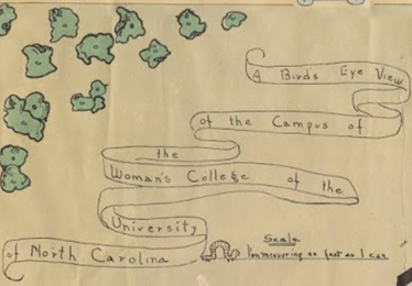
“A Bird’s Eye View of the Campus of the Woman’s College of the University of North Carolina”—Inspired by the Library of Congress exhibit about women as mapmakers, Luke Simandle contextualized the pictorial border and other cartographic features Aderholt used in playful ways, like the inchworm scale. He investigated how she might have learned about mapmaking as a Women’s College student.
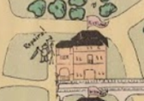
The New Deal and the Depression:The impact of New Deal Administrations on the Woman’s College of the University of North Carolina—Carlos Diaz brought new meaning to the drawing of workers repairing Kirkland dorm in his research about the impact of New Deal programs on campus infrastructure. A 1933 Carolinian article about Civil Works Administration money for repairs and improvements emphasized that “the dormitories, too, will come in for their share of improvement.”
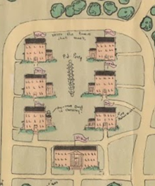
“P. J. Party” in the Quad—Nikki Waller discovered a book about the architectural history of the American Dormitory that helped her understand the significance of the quad as a new form of student residential and social space at Woman’s College, private enough to host a pajama party on the lawn.
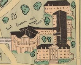
The cafeteria as “Food’s Paradise”—Halenia Phillips was drawn to study the ways that Home Economics students represented food on the map at a time of scarcity. She researched the academic training that took place in food labs at the Home Management house and the social role of food on campus in the 1930s.
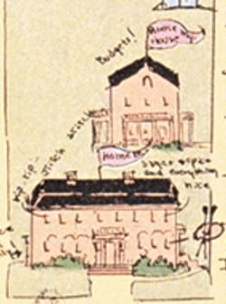
The Home Economics building and Home Management House—Daniel Collins worked to understand the role of the Home Economics Club in creating the map and the training they received as Home Economics majors that bridged domestic and professional roles and responsibilities.
Alice Haddy says:
What a wonderful map! I ran across it a couple years ago when I wanted to understand the layout of campus during the heyday of the Woman’s College. So much to see here!